
Yesterday I was visiting friends in Spokane and we heard a DC 10 air tanker, the kind that holds water for fires go over us. A man who saw the tanker identified it for us as I was under a patio cover. {see photo below]

| Douglas DC-10 | USA | 12,000 US gallons (45,000 L) |
I looked up the fires in Spokane area today to see what has been going on. We had a lot of smoke on and off for since I have been here July 15, 2015.

Photo from the Smoke Aug 2, 2015 from this blog at Washington State Smoke from Fires Information
A fire reported in this link http://www.spokesman.com/stories/2015/aug/08/two-fires-burning-northwest-spokane/
August 8, 2015 in City
West Plains fire forces evacuations of dozens of homes
Nina Culver The Spokesman-Review
Dozens of homes were evacuated late Saturday afternoon as a fast-moving fire quickly consumed 270 acres on the West Plains.
A chicken coop and another structure burned, but no homes had been lost by late Saturday.
“At first it was so hot there we had spot fires. Trees were torching,” said Assistant Spokane Fire Chief Brian Schaeffer, one of many firefighters from numerous jurisdictions called to the scene.
It was heading toward homes, but air tankers dumped retardant and water on the fire repeatedly, and it calmed, he said.
The fire, which consumed brush, timber and grass, started about 4:30 p.m. at 21251 W. Coulee Hite Road, said Spokane County Fire District 10 Chief Nick Scharff. It likely was human-caused, but remains under investigation.
Here is a link to all the fires in Washington state, the Spokane area.
Map at:
http://www.arcgis.com/apps/PublicInformation/index.html?appid=0c12ac1e89c24075a2be145f4db6caf5&extent=-117.9401,47.6526,-117.3825,47.8921
Here is a screenshot of the map today. When you go to the link above you will be able to zoom in and out and check on each fire.
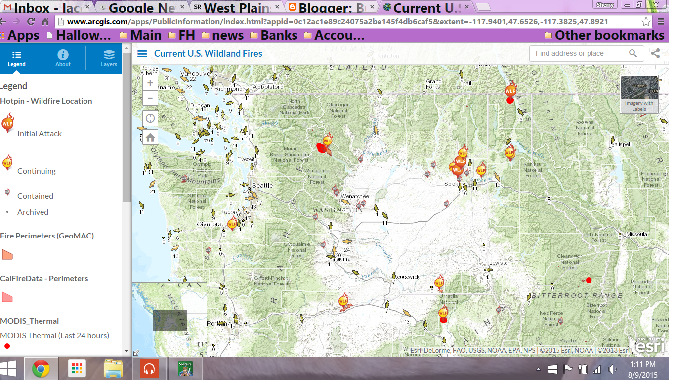
Map of current fires in the Pacific North West of the USA Aug 9, 2015
I found a facebook page for the fires called Wolverine Fire which has up to date information and photos.
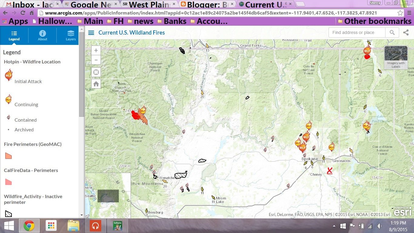
Close up of fires in the Spokane area - The area where I am currently living is above the RED X - east of Spokane
In the upper left area of the map in the Wenatchee area and Chelan, these fires have been the one's that the smoke comes to the Spokane area and stays in the inversion or this area.
The Fire in this area is called the #Wolverinefire which was started by Lightning on Monday June 29th, 2015.
From the Wolverine Fire Map Washington State fires map link
Current Fire Perimeters: Wolverine
1. The Wolverine fire has burned approximately 28,830 acres as of August 7, 2015. This information is updated ~24 hours (USGS.gov, GeoMAC).
2. Wolverine Fire burned 28,830 acres on August 8, 2015.
3. There has been a "hot spot" identified within 1 km of this location. Detected by the T satellite this hot spot could be a wildfire. Hot spots are used as early detection methodology by fire agencies.
Hot Spot observed date:8/7/2015, 11:40 PM
Hot Spot brightness: 307.10

Map of the Wolverine Fire Aug 9, 2015
The Wolverine fire has burned over 28,830 acres and was started on
Updates from the link below:
QUICK FACTS - INCIDENT SUMMARYApproximate acreages: Wolverine Fire - 28,725 acres; Blankenship - 111 acres; Goode Fire - 605 acres
Fire Containment: 20%
Resources on the Fire: Crews - 14; Engines - 19; Water Tenders -10; Bulldozers - 4; Helicopters - 8
Total Personnel: 594
Structures lost: 1 residence and 3 minor structures
Jurisdiction: USDA-Forest Service; National Park Service; Washington State DNR; Chelan County Sheriff; Chelan County Fire Districts #7 and #10
Wenatchee National Forest > Wolverine Fire
FOR FURTHER INFORMATION, visit Okanogan_Wenatchee National Forest: Okanogan_Wenatchee National Forest
and Incident Information System
This is what the above link has about the Wolverine fire and when it started:
Basic Information
| Current as of | 8/9/2015, 5:52:44 AM |
|---|---|
| Incident Type | Wildfire |
| Cause | Lightning |
| Date of Origin | Monday June 29th, 2015 approx. 07:30 AM |
| Location | 3 miles NW of Lucerne, WA |
| Incident Commander | Chelan Ranger District/ USFS |
| Incident Description | Remote, Extremely Steep Area |
Current Situation
| Total Personnel | 594 |
|---|---|
| Size | 28,725 Acres |
| Fuels Involved |
Timber (grass and understory)
Timber (litter and understory)
|
| Significant Events |
Active, torching, spotting, and wind driven runs.
|
No comments:
Post a Comment
Thank you for your comment! However, if you are just commenting to get me to come look at your page because you are selling something, I will delete your post.